HARE MOUNTAIN 100
ABOUT
The HM100 is October 24th, 2025-5:00AM at Haw Creek Falls Recreation Area.
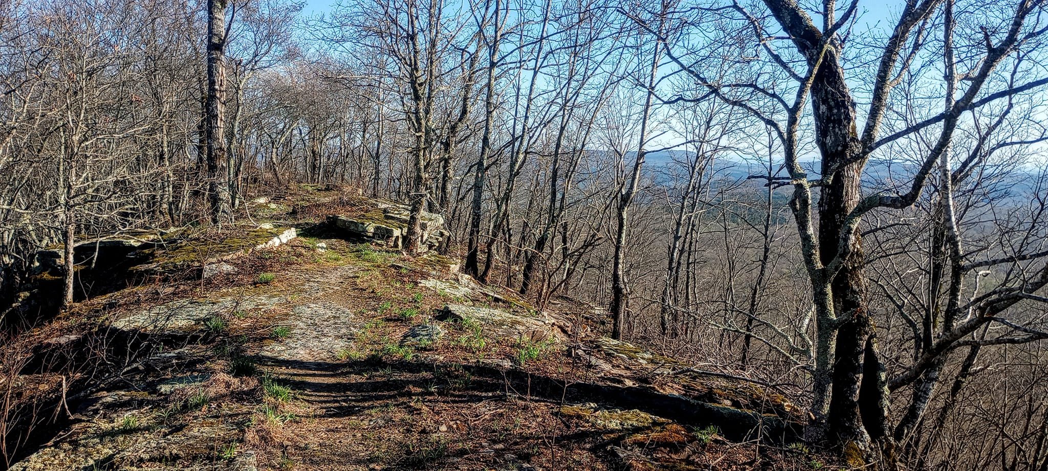
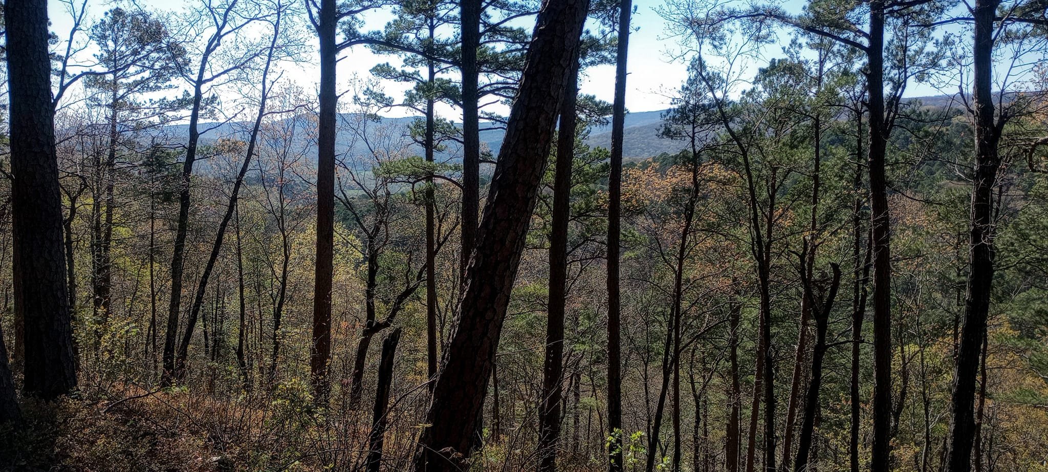
The Hare Mountain 100 is a point-to-point, graduate level run through the most isolated, rugged terrain in Arkansas. It is extremely difficult. Big climbs and relentless smaller, steep climbs in between.
The Ozark Highlands Trail is hiked by thousands of people every year. While very remote, it is not a primitive, unmarked trail by any means. It is a National Scenic Trail maintained by volunteer members of the Ozark Highlands Trail Association.
But, please do not sign up if you are not comfortable with:
-being self sufficient
-limited to no extra marking beyond trail blazes and wooden trail signs
-navigation
-carrying a little extra gear for your safety.
-long distances between major aid stations
A GPS tracking device with the course GPX downloaded is a requirement. It will be checked during check-in to make sure you have it. While the trail is marked very well with white blazes for the main trail and blue blazes for the spurs, turns can be missed. Sometimes trees fall where the trail turns. Sometimes the tree with the blaze falls. Sometimes leaves cover the trail. Sometimes it's foggy. It's the wilderness. It's a raw and incredible experience. Be confident you can stay/get back on course.
This is a 100 mile adventure run that incorporates 2 scenic spur loops along the Ozark Highlands Trail. It is located in the Northwestern part of Arkansas across the Boston Mountain segment.
Hare Mountain is the highest point on the OHT at ~2400 feet. This segment covers 164 miles of rocky, steep and rugged hardwood, cedar and pine forests. I'm utilizing 100 miles of the most difficult sections.
There are several creek crossings, amazing wildlife, incredible fall colors, waterfalls, bluffs and beautiful sandstone outcrops.
I grew up on this trail. It means a lot to me to bring such a wild and challenging experience to runners.
Measurements taken by GPS and topographic mapping have put elevation gain between 20,000-24,400 feet. It depends on the device/app. Runners will have 38 hours to complete the 100 mile run.
There will be 6 major aid stations with crew access and drop bags. Crew is always allowed to feed and care for their runner within the aid station boundary but not outside of that.
1. Ozone-mile 17
2. Arbaugh-mile 31
3. Indian Creek-mile 50
4. Redding-mile 61
5. Morgan Field-mile 67
6. Shores Lake-mile 100-FInish
There will be 6 light aid stations as safety checkpoint (FSR1004, Moonhull, CR6200, Cherry Bend, Black Mountain/Ragtown Rd, Salt Fork/White Rock).
You cannot leave a car at the start unless you have someone meeting you as crew and able to take you from finish to start. If you are 100% solo, you will park at the finish at Redding Campground and get shuttled to the start Friday morning.. If you do not finish, and you do not have crew, you wil wait at the aid station where you drop until someone can take you to your car at Redding (or you can pay for a private shuttle if you do not want to wait).
If you park at the start without crew, you will not get a ride back unless you pay our shuttle driver. Or get lucky another crew is going that direction and has room for you.
In 2025 we are planning to add a 200 mile run the same week(end) as the 100. Details wil be available as course comes together with the forest service.
https://www.facebook.com/groups/216147591049546/
https://www.instagram.com/haremountain100/
https://ultrasignup.com/register.aspx?did=103630
“Thank you for putting on the race that tested my mental and physical ability more than any other thing on Earth. Also, the belt buckle is the prettiest, coolest buckle I have earned so far.”—HM 100 finisher 2024


THE COURSE

AID STATIONS
Runner Information and Race Rules
Race Day: There will be no pre-race briefing the morning of the race. Everything you need to know will be sent to the email you used to sign up for the race (documents, videos, etc). The same information will be in a Google Doc and probably posted in the Facebook group and on the FB page.
We are LNT advocates. Make sure you pick up your trash and help other runners if they drop theirs.
Tracking: We will be using MAProgress to live track each runner. If you are using your own device you will be guided through how to register your device with MAProgress. If you do not have a device, you can borrow one from a friend or rent one from MAProgress for $45 (you will be provided a link to connect with MAProgress). We will also use OpenSplitTime for live results.
We will be using a combination of Starlink, Satellite 2-way communicators and cell phones to stay in contact with runners, crews, medical, rescue and aid stations.
We take your safety seriously.
Mandatory gear: The weather in Arkansas in late October could be 70 and sunny, raining and 38, snowing or in the 40's and sunny. The temps will be cold to chilly at night with a decent possibility of freezing temps.
If the weather is good for the start and most of the daylight hours Friday, you can put the extra clothing in your drop bag at Arbaugh (mile 32) or Indian Creek (mile 51). We will check gear at those 2 stations. You must carry everything for the night portion.
-GPS tracking device with course GPX downloaded.
-Phone at all times
-Bivy or emergency blanket (I prefer bivy)
-2 headlamps (carry one at all times and 2 after Aid 5.
-Rain jacket with hood and taped seams
-Long sleeve (preferably wool)
-Full leg covers of any type
-Whistle
-Beanie
-Water filtration (I carry a Katadyn BeFree or Life Straw depending on what I'm doing)
-Gloves
Recommended gear:
-Small portable chargers for phone, watch, GPS device
-Socks at every drop bag. Lots of creek crossings.
-Blister kit
-Anti chaffing cream or Vaseline. One of our sponsors, Squirrel's Nut Butter, will be providing a tub at aid stations.
-Gels, energy chews, etc
Pacers:
Can pick up pacers at Aid 4, Arbaugh, mile 31. Pacers must sign a waiver and get a bib at aid station they are starting from. One pacer at a time. Pacers must be picked up at aid stations only. No muling. No car rides. No aid outside of aid stations.
Pregnancy Deferrel
Any runner who becomes pregant and cannot attend the event, will be offered a 100% deferrel to the next year.
Aid Station Suppies (most aid stations will have a selection from the list). The 6 major aid stations will have hot food. Light aid stations will have typical aid station fare but do not count on hot food at these locations. If the volunteers at lighter aid feel they can get all of the required gear to these more remote spots to make that possible, they will.
Tailwind Potato Soup Broth
Soda Ramen Tampons
Oreos Sphaghetti Pads
Chips Quesadillas First Aid Kits
Potatoes PBJ Ant chaffing balm
MMs Bacon Avocado
Coffee Quesadillas Honey
Grilled Cheese Burgers (veggie option) GU Energy Gels
Our Volunteers and Feedback From Runners
Runners and their crew will be friendly and respectful to our volunteers who are giving their time, to take care of you. They are doing the best they can. You will be pulled from the race if you are disrespectful in any way.
If you have feedback, epsecially negative feedback, we would love to hear it. But either pull us aside or wait until after the race. It is not allowed in any aid station. It is disruptive and distracting for other runners, crews and volunteers.


Our Commitment to Leave No Trace
While moving forward we are not marking the course at all with anything beyond the white and blue blazes and wooden trail signs, we are offering 2-3 free slots to runners who want to sweep the course picking up any possible trash dropped by a runner. These 2runners will have to stay together, have their own GPS tracking device (or rent) and cover the entire course. They will get credit for the 100 as our official DFL's and receive a buckle. Interested parties must email us and get a code.
We have a strong commitment to leaving the trail clean. We were a minimal marking race to start with. But we're taking it a step further. LNT.
Follow us on social
Wilderness Endurance
SPONSORS and PARTNERS
STOOLVILLE